Skip links

Mostaqbal Systems

Unique digital Ideas

We help our clients succeed by creating brand identities, digital experiences, and print materials.

Everything you need from
strategy to
success

We provide customized solutions and services to various industries.

Consulting Services

System design, optimization, industry strategy, finance crimes, and business planning.

Outsourcing Management

On-site, remote, hybrid, and dedicated staff tailored to business requirements.

Training

Certified instructors offering online courses, on-job learning, and expert advisory.
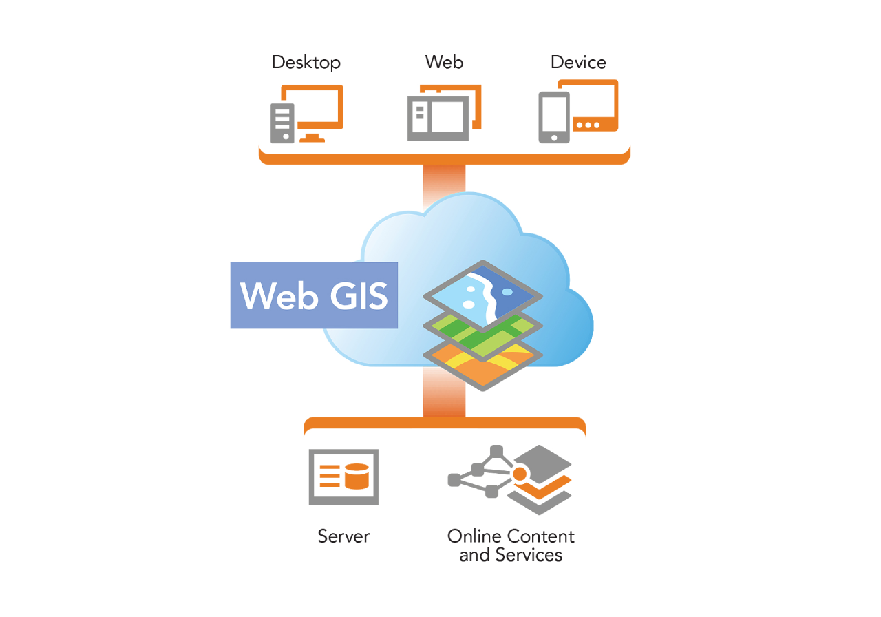
IT Services

Microsoft, database, and cloud services with ERP, web development, and digital transformation.
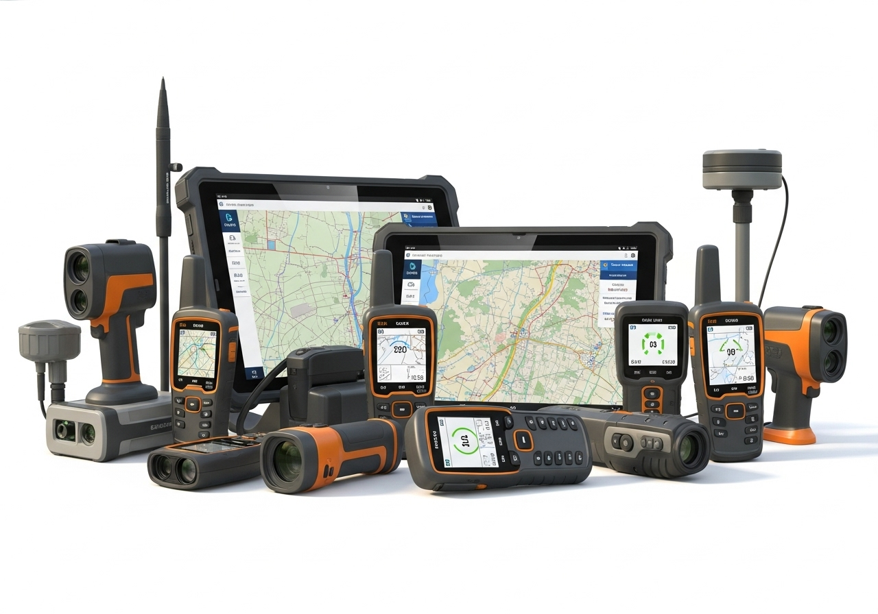
Satellites Imagery

Remote sensing, satellite imagery access, data analysis, and advanced processing solutions.

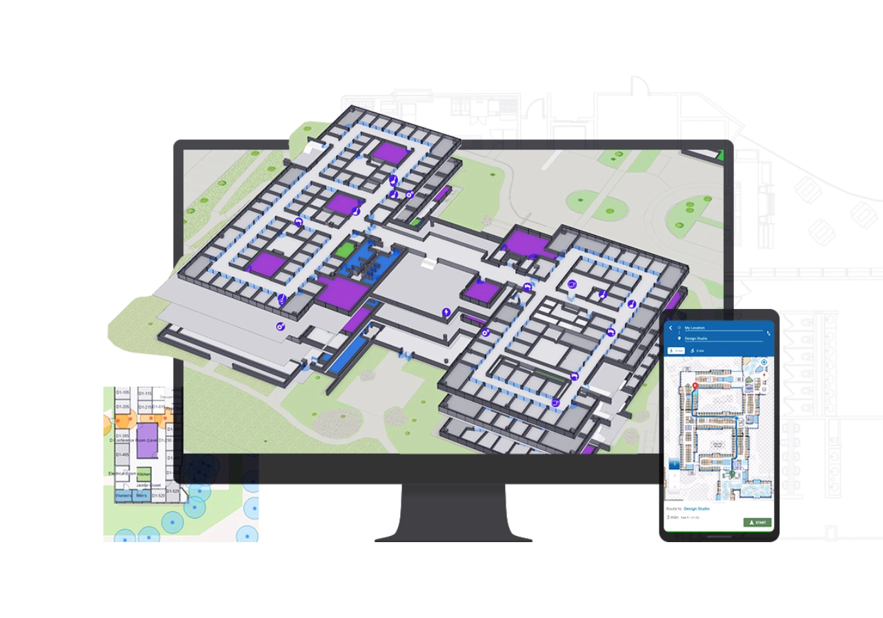
Software & Apps Development

Custom applications, geo-integration, and web & mobile development with ArcGIS SDKs.

Professional Services

Enterprise GIS deployments, geospatial solutions, financial systems, and business integration.

Technical Support 24/7

Annual technical support, pay-as-you-go services, and premium advantage programs.

Esri Services

Data conversion, quality control, AI-powered analysis, and urban planning solutions.

Digital Marketing

PR, social media, events, production, and website management strategies worldwide.

ARCGIS

ARCGIS ENTERPRISE

ARCGIS DEVELOPMENT

3D MAPPING

We provide end-to-end GIS solutions that connect data to maps for smarter insights and decision-making. From powerful mapping in 2D, 3D, and real-time, to advanced spatial analytics enhanced by AI, we help organizations uncover patterns and relationships with geographic context. Our services also cover robust data management—ensuring accurate editing, seamless sharing, and reliable systems of record across the enterprise.

We deliver complete ArcGIS Enterprise solutions—the core system for mapping, analytics, and data management. From installation and high-availability deployments on-premises or cloud, to creating custom maps, apps, and interactive visualizations, we empower organizations with scalable GIS. Our services also include customization and automation to streamline workflows, boost efficiency, and unlock the full potential of the Esri ecosystem.

We build powerful custom applications using ArcGIS Maps SDKs for web, mobile, and desktop, enabling advanced visualization, interactive analysis, and offline use. From native apps with .NET, Swift, Kotlin, Flutter, and Qt across all platforms, to automated GIS workflows with Python, notebooks, deep linking, and webhooks—we deliver tailored solutions that streamline operations and extend GIS capabilities to meet business goals.

We deliver advanced 3D mapping and Digital Twin solutions that integrate real-world data into immersive virtual environments. From creating entire cities at once to connecting CAD, BIM, and Revit with GIS, we enable smarter planning, real-time construction monitoring, and proactive decision-making. Our solutions empower industries like real estate, healthcare, and manufacturing with precise spatial insights for sustainable and resilient growth.

Our Solutions

Empowering diverse industries with innovative solutions tailored to drive growth and transformation

OUR Solutions

Empowering diverse industries with innovative solutions tailored to drive growth and transformation

Oil & Gas

Streamlining Exploration, Production, and Transportation with Smart Digital Solutions

Upstream

Optimizing exploration and production processes by leveraging advanced location-based insights.

Our consultation, ArcGIS services, and digital solutions help in identifying resources, planning extraction efficiently, and minimizing operational risks.

Midstream

Enhancing transportation, storage, and pipeline management through smart mapping and digital monitoring. Integration of consultation.

ArcGIS services, and digital solutions ensures safe, efficient, and data-driven operations across the supply chain.

Our ArcGIS Expertise

We provide customized solutions and services to various industries.

GIS Applications

Deploy integrated, location-based apps that work wherever you go

Field Operations

Boost efficiency in field tasks using the full power of location data

Spatial Data and Remote Sensing

Geospatial system for imagery insights and clear decisions

3D Gaming and Digital Twin

Add 3D to geospatial data for insights and better decisions

Indoor Solutions

Extend transit asset life and ensure safe, reliable service with smart management

Read the latest news

We provide customized solutions and services to various industries.

Shaping the Future withTechnology

Partner with Mostaqbal Systems for Digital Success

We deliver smart GIS, IT, and digital solutions that turn challenges into opportunities and drive growth, efficiency, and innovation.